 |
||||||||
|
||||||||
|
The
Historic Roads Project
Every day we are finding new (old) roads in Ringwood State Park that have historical significance. These roads lead past 18th century mines, 19th house foundations, prehistoric Indian Rock shelters, streams, lakes, furnaces and foundries. 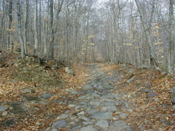
Because of the proximity to ports and the availability of iron, Northern New Jersey was one of the first areas settled by the Europeans in North America. In the Adirondacks (where I grew up) there are few old roads, because, in the 1700s, the only people there were Indians and trappers. But Passaic County is a network of historic trails. The Ringwood/Long Pond RoadWhen Hasenclever first settled the Ringwood area to build an iron industry, one of his greatest challenges was to build roads over rocky, forbidding terrain. Some of these roads have formed the basis for our highways today, but others are forgotten, dimly seen paths in the woods. When Robert Erskine took over Hasenclever's position, he also took over responsibility for keeping the roads to the other ironworks clear. But Erskine did more than that - he made maps of the roads. From one of his 18th Century maps, we can see that there was a major route between Ringwood and Long Pond. This road winds through the mountains and past other sections rich in ore. By the 20th Century the road disappeared from the maps, but you can still see a thin trail in aerial photographs. One of the projects of Ringwood Manor and Long Pond Ironworks is to mark this road in its entirety for use as a historic trail. 
The project is now complete and, thanks to the Palisades Park Commission and the NY/NJ Trails Conference, the trail is open to the public. Much of the 200+ year old road is unmistakable - it was used so heavily by horses carting iron that it has been worn three or more feet into the ground. But other sections have been re-routed around swamps. The largest change is at the Long Pond side where the road probably went through the reservoir. You can click on the map above to see a larger version, suitable for printing. You can also get the official NY/NJ Trails Converence map at http://www.nynjtc.org/trails/newtrails/hasenclever.html. See also Friends of Long Pond Ironworks.
|
|||||||
History | Architecture | People | Iron Industry | Tours | Contacts | Home Directions to Ringwood Manor |
||||||||